Bienvenido!
La Red Latinoamericana de Teledetección e Incendios Forestales (#RedLaTIF) es una red regional que pretende unir esfuerzos en el campo de la observación y gestión de los incendios forestales en todos los países latinoamericanos. Esta red está estrechamente unida al programa Global Observations of Forest and Land Cover Dynamics (GOFC/GOLD), la cual intenta contribuir en el cumplimiento de los objetivos de dicho programa.
Nuestra más reciente actividad.
Webinar RedLaTIF 2021
Herramientas para el Mapeo de Áreas Quemadas (BAMT) en GoogleEarthEngine
Ekhi Roteta estudió el grado en Ingeniería en Geomática y Topografía en la Universidad del País Vasco (UPV/EHU), con el último año realizado en la universidad suiza de Haute École d’Ingénierie et de Gestion du Canton de Vaud (HEIG-VD), continuando su trabajo en el ámbito de la detección de áreas quemadas.
Con el auspicio de:
Red Latinoamericana de Teledetección e Incendios Forestales – http://www.redlatif.org/
Fundacion Amigos de la Naturaleza https://www.fan-bo.org/
Geoinformacion https://cursogeoi.com/
RedLaTIF
Los miembros de la red se reunieron en NOAA, Estados Unidos, la primera semana de octubre 2018. La reunión se realizó con el apoyo de START.

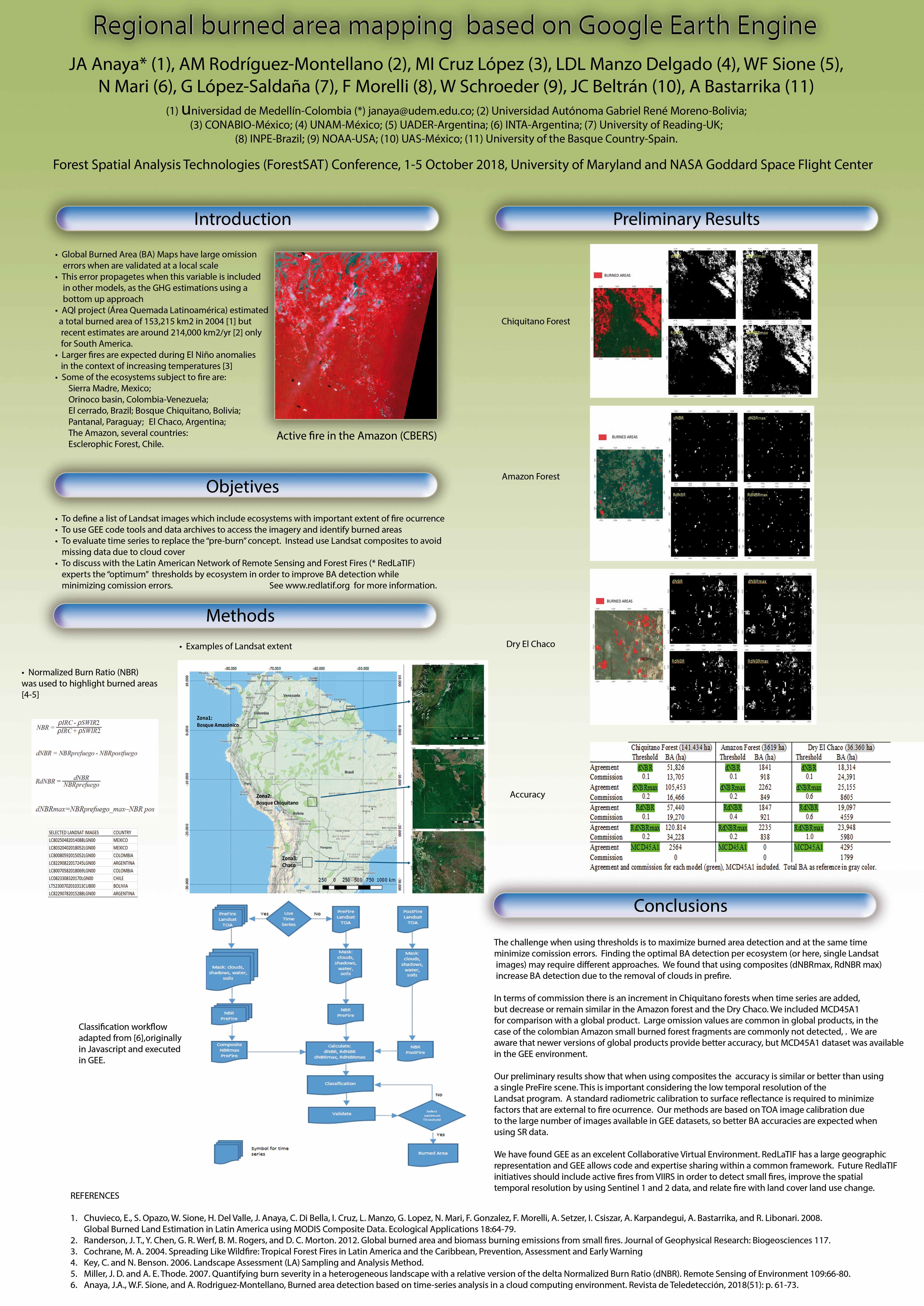
Desde la última reunión en INPE la red viene utilizando GEE para evaluar el uso de las series de tiempo en la detección de áreas quemadas. Para ello han refinado modelos basados en dNBR donde se ha generado un compuesto en prefuego con valores máximos de NBR y se han filtrado las nubes, las sombras de las nubes y los suelos desnudos. Los resultados se presentaron en PÓSTER en ForestSAT 2018, organizado por The University of Maryland y NASA goddard space flight center.
Leer el reporte del taller en NOOA 2018
RedLatIF estuvo presenté en el simposio SELPER Argentina 2016 y en la conferencia de ForestSat Chile 2016 se hicieron varias presentaciones de la red y los proyectos actuales. De resaltar la presentación de Alberto Setzer, por el valor agregado (reportes, tablas, resúmenes consolidados, etc) que tienen los productos de INPE de focos de calor. Las presentaciones se pueden descargar de la página de GOFC-FIRE:
Detección de área quemada con Google Earth Engine
Presentación INPE Ver también: www.inpe.br/queimadas